
Autonomous Mars Rover Navigation
This project improves the autonomous navigation of the FHNW Mars Rover. The path-finding uses better cost map generation, the navigation can follows arcs and obstacles are detected using the new Lidar sensor.

Picture of the FHNW Mars Rover, with the FHNW Mars Yard, height map and cost map in the background.
Initial situation
The FHNW Rover Team competes at the European Rover Challenge (ERC) for the fourth time in 2025. The ERC is an international space robotics competition to foster interest and innovation. Different tasks have to be solved by the teams and their rovers, for example performing maintanance, taking surface samples and navigating through the terrain. For the Navigation Task the rover needs to traverse a set of given waypoints as autonomously as possible. The autonomous navigation system of the FHNW Mars Rover should be improved for the ERC 2025.
Problem statement / Project goal
The goal of this project is to improve the autonomous navigation of the FHNW Mars Rover to be more flexible and dynamic. It worked at the ERC 2024, but there were shortcomings requiring luck to arrive at the good result we achieved (3rd place for the Navigation Task).
- The path-finding should be improved to make better use of the available elevation data. The path should use the 2.5D distances from the height map. The term 2.5-dimensional is used to describe 2D data structures that use an attribute or value to store a third dimension (in contrast to use a real 3D data structure).
- The path and should use arc lines, so the rover can make use of it's driving capabilities and drive along curves. At the ERC 2024 the rover didn't turn in the direction it was moving, it just turned the 360° adjustable wheels to change course. That crab-walk looked impressive, but caused unfavorable angles when approaching valleys or ramps and most often the rover's most important sensors would point in a random direction instead of forward.
- The rover should make use of the new Lidar sensor, providing accurate 3D data about the environment, giving better results that the stereo camera. The rover should use this information to detect and avoid obstacles. This allows the rover to react to changes in the environment dynamically and handle potential localization errors gracefully.
Cost Map
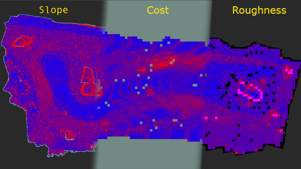
The cost map (middle) is created by a combination of the slope (gradient, left) and the roughness (diversity of gradients, right) of the terrain. Steep terrain is more difficult to naivgate, and rough underground is harder too.
Arc Lines
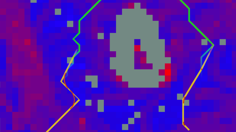
By default, the generated path is not very smooth and shows many zig-zag patterns (top, green). The path is smoothed by skipping corners close enough to the rest of the path (bottom, yellow). The corners are then softened by fitting an arc (red).
Lidar
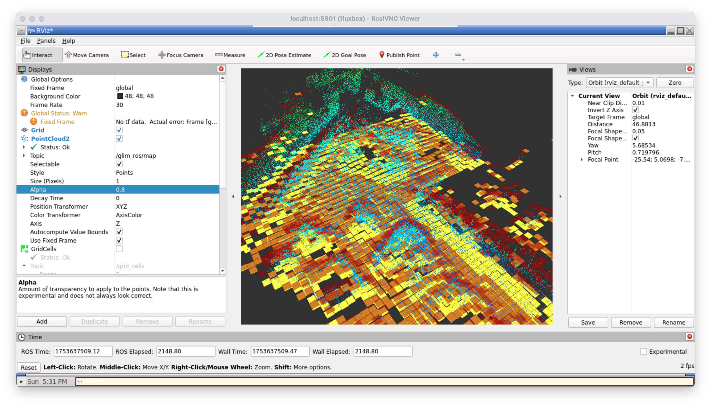
The point-cloud from the Lidar sensor visualized in RViz. The point-cloud is color-coded with the heigt of the point, mostly showing green and blue-ish here. The red and yellow squares are estimations of the elevation in the respective area.
Solution developed and its benefits
The navigation system was improved in all layers to be more safe and dynamic. The system assumes a working localization since it's not part of this project. The Robot Operating System ROS is used to control the rover, providing an architecture where nodes send messages to each other.
- The height map is created using the Composite feature in Blender, making it easier to correctly normalize the values to get the maximum precision.
- The cost map is now generated in a ROS node, better fitting into the rest of the system and making dynamic recalculation of the cost map possible.
- The cost map uses a lower resolution to reduce jitter. To not loose all of the information from the higher resolution, a metric for roughness is included in the cost map as well.
- The cost map and the various interim maps are published as ROS topics, so RViz can be used for visualization and other nodes could make use of them too.
- The path-finding uses the lower resolution cost map, reducing turns to avoid stones too small to be relevant.
- The path is post-processed and corners are replaced with arcs, enabling the rover to drive along curves. The traversing system is updated accordingly to make use of the new arc line path.
- A new node processes the point-cloud from the Lidar to estimate the elevation around the rover.
Together, these changes are a substantial improvement for the autonomous navigation system. More testing is needed before the final challenge, the ERC 2025 in Kraków, Poland.
Key terms
- ConceptsAutonomous Navigation, Arc Lines, Path-finding, Obstacle avoidance
- HardwareRover, Lidar, Stereo Camera, Drivetrain
- SoftwareRobot Operating System (ROS), C++, BehaviorTree